Turn on suggestions
Auto-suggest helps you quickly narrow down your search results by suggesting possible matches as you type.
Cancel
- Home
- :
- All Communities
- :
- Industries
- :
- Education
- :
- Education Blog
- :
- Analyzing the Best Route and the Closest Facility
Analyzing the Best Route and the Closest Facility
Subscribe
325
0
07-04-2013 11:00 PM
- Subscribe to RSS Feed
- Mark as New
- Mark as Read
- Bookmark
- Subscribe
- Printer Friendly Page
- Report Inappropriate Content
07-04-2013
11:00 PM
I recently created a set of activities based on using web-based GIS tools to teaching spatial thinking using drive-time..., another set of activities that use viewsheds, and another on the use of zonal statistics. Typical modern GIS tasks also include determining the best route and the closest facilities to specific locations. This is important for a wide range of applications, from emergency services bringing people in an ambulance to the nearest hospital to the nearest competitor to your planned new bicycle rental facility.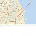 Open this web map and click somewhere on the map in northeastern San Francisco that represents a location where let's say you are currently located. What is the closest facility to your chosen point? Change the choice under the map to find the routes for the 1 closest facility to a point to 2 closest facilities. Two routes are shown in this image; I selected one of them, highlighted in cyan, and the directions are given for this route.
This tool is easy to run with the above link and yet can lead to so many wonderful discussions about the Can you think of real-world situations where a route to two or more closest facilities would be needed from a given point, besides the emergency and bicycle examples I gave above? Name them and discuss why this type of analysis is so critical to our 21st Century world.

Finding the Route and the Closest Facility to a chosen point.
This tool is easy to run with the above link and yet can lead to so many wonderful discussions about the Can you think of real-world situations where a route to two or more closest facilities would be needed from a given point, besides the emergency and bicycle examples I gave above? Name them and discuss why this type of analysis is so critical to our 21st Century world.
You must be a registered user to add a comment. If you've already registered, sign in. Otherwise, register and sign in.
About the Author
I believe that spatial thinking can transform education and society through the application of Geographic Information Systems for instruction, research, administration, and policy.
I hold 3 degrees in Geography, have served at NOAA, the US Census Bureau, and USGS as a cartographer and geographer, and teach a variety of F2F (Face to Face) (including T3G) and online courses. I have authored a variety of books and textbooks about the environment, STEM, GIS, and education. These include "Interpreting Our World", "Essentials of the Environment", "Tribal GIS", "The GIS Guide to Public Domain Data", "International Perspectives on Teaching and Learning with GIS In Secondary Education", "Spatial Mathematics" and others. I write for 2 blogs, 2 monthly podcasts, and a variety of journals, and have created over 5,000 videos on the Our Earth YouTube channel.
Yet, as time passes, the more I realize my own limitations and that this is a lifelong learning endeavor and thus I actively seek mentors and collaborators.
Labels
-
Administration
38 -
Announcements
45 -
Career & Tech Ed
1 -
Curriculum-Learning Resources
179 -
Education Facilities
24 -
Events
47 -
GeoInquiries
1 -
Higher Education
519 -
Informal Education
266 -
Licensing Best Practices
46 -
National Geographic MapMaker
11 -
Pedagogy and Education Theory
187 -
Schools (K - 12)
282 -
Schools (K-12)
185 -
Spatial data
24 -
STEM
3 -
Students - Higher Education
231 -
Students - K-12 Schools
86 -
Success Stories
22 -
TeacherDesk
1 -
Tech Tips
83
- « Previous
- Next »