Turn on suggestions
Auto-suggest helps you quickly narrow down your search results by suggesting possible matches as you type.
Cancel
- Home
- :
- All Communities
- :
- Industries
- :
- Education
- :
- Education Blog
- :
- Reflections on Terraserver and the Evolution of Da...
Reflections on Terraserver and the Evolution of Data for GIS
Subscribe
673
0
10-11-2012 11:47 PM
- Subscribe to RSS Feed
- Mark as New
- Mark as Read
- Bookmark
- Subscribe
- Printer Friendly Page
- Report Inappropriate Content
10-11-2012
11:47 PM
Back in 1998, I and my colleagues were thrilled with the arrival of Terraserver. While maps and images for use in GIS on the web today are commonplace, back then it was revolutionary. Suddenly, thanks to an agreement between the USGS and Microsoft, the GIS community had access to USGS topographic maps and aerial photographs down to 1 meter spatial resolution for the entire USA. Two additional features made this service extra special. First, these images were georeferenced, meaning that they could be easily used within a GIS environment. Second, these images were online: No CD-ROMs or other physical media were required! After downloading the maps and aerials for our area of interest, we could read these maps and images into our ArcInfo or ArcView GIS software. True, the header files often needed to be edited first, but this resource gave us a huge leap forward because we had terabytes of data at our fingertips via http://www.terraserver-usa.com, later becoming http://msrmaps.com. Even better was when some enterprising folks at Esri wrote programs to automatically stream these images to ArcGIS.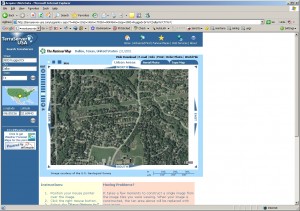
Now, 14 years later, Terraserver was recently retired. As the National Atlas recently wrote, “We note its passing and salute all those who developed the service. Many people were involved in this groundbreaking effort. Still, there were three individuals who largely provided the vision and hard work that resulted in this remarkable service: Tom Barclay (Microsoft), Beth Duff (USGS, deceased), and Hedy Rossmeissl (USGS, retired). The National Atlas switched over to services provided by Esri so that Atlas users can continue to link from our maps to large-scale topo maps and aerial views. This takes us full circle. The National Atlas Map Maker was the first on-line, interactive mapper offered by the Federal government. It was partially developed under a joint research effort by the USGS and ESRI
in 1997.”
A plethora of base maps, topographic maps, satellite images, and aerial photographs are now available to the GIS user and the general public such as via ArcGIS Online. Times have changed but the need for good base data lives on. While I don’t long for those days of tinkering with header files, I salute the early pioneers who made it all happen, and look forward to the future. The evolution of GIS data, and discussion about data sources, quality, and related issues are detailed and blogged weekly about in the book that Jill Clark and I wrote, entitled The GIS Guide to Public Domain Data.
I and my colleagues frequently need old aerials for land use change studies, however, and therefore, I wish Terraserver had remained online. Why couldn’t it have done so? What are now the best sources for old aerial photographs?
- Joseph Kerski, Education Manager, Esri
You must be a registered user to add a comment. If you've already registered, sign in. Otherwise, register and sign in.
About the Author
I believe that spatial thinking can transform education and society through the application of Geographic Information Systems for instruction, research, administration, and policy.
I hold 3 degrees in Geography, have served at NOAA, the US Census Bureau, and USGS as a cartographer and geographer, and teach a variety of F2F (Face to Face) (including T3G) and online courses. I have authored a variety of books and textbooks about the environment, STEM, GIS, and education. These include "Interpreting Our World", "Essentials of the Environment", "Tribal GIS", "The GIS Guide to Public Domain Data", "International Perspectives on Teaching and Learning with GIS In Secondary Education", "Spatial Mathematics" and others. I write for 2 blogs, 2 monthly podcasts, and a variety of journals, and have created over 5,000 videos on the Our Earth YouTube channel.
Yet, as time passes, the more I realize my own limitations and that this is a lifelong learning endeavor and thus I actively seek mentors and collaborators.
Labels
-
Administration
38 -
Announcements
45 -
Career & Tech Ed
1 -
Curriculum-Learning Resources
179 -
Education Facilities
24 -
Events
47 -
GeoInquiries
1 -
Higher Education
519 -
Informal Education
266 -
Licensing Best Practices
46 -
National Geographic MapMaker
17 -
Pedagogy and Education Theory
187 -
Schools (K - 12)
282 -
Schools (K-12)
185 -
Spatial data
24 -
STEM
3 -
Students - Higher Education
231 -
Students - K-12 Schools
86 -
Success Stories
22 -
TeacherDesk
1 -
Tech Tips
83
- « Previous
- Next »