Turn on suggestions
Auto-suggest helps you quickly narrow down your search results by suggesting possible matches as you type.
Cancel
- Home
- :
- All Communities
- :
- Industries
- :
- Education
- :
- Education Blog
- :
- Siting a Bicycle and Ski Equipment Sales and Renta...
Siting a Bicycle and Ski Equipment Sales and Rental Shop in Wisconsin
Subscribe
437
0
08-10-2012 02:08 AM
- Subscribe to RSS Feed
- Mark as New
- Mark as Read
- Bookmark
- Subscribe
- Printer Friendly Page
- Report Inappropriate Content
08-10-2012
02:08 AM
I created a lesson where students determine the optimal location for a bicycle and ski rental and sales shop using Esri’s Community Analyst software. The lesson begins with a scenario where the student’s task is to select the best site near one of the oldest and most beautiful rail-to-trail segments in the country—the Sparta-Elroy Trail in west-central Wisconsin. I have personally bicycled this trail, including its three famous railroad tunnels, and sometimes those personal connections to the area being studied make curriculum creation all the more enjoyable, and, I hope, valuable.
Students using the lesson examine local terrain, proximity to towns, the trail (shown by the thick green line in the image), interstate highways, campgrounds, and state parks, the area’s population, median income, amount of money spent by regional households on bicycling equipment in the past year, and the location of existing bicycle rental and sales shops. They also consider customers who would rent versus own the equipment, and consider how winter sports such as cross country skiing, snowshoeing, and snowmobiling would impact the shop’s year-round and overall viability.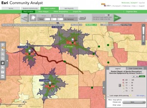
I chose Esri’s Community Analyst platform for several reasons. The platform is cloud-based, and as no software is needed, accessing the toolkit is as easy as accessing a web browser and logging into Community Analyst. Some universities have access to this toolkit already, so check with your university. If the software is not part of your university license agreement, you can request a 30 day free trial. Better yet, ask your university Esri software point of contact to add Community Analyst in the future. The toolkit can easily create reports, thematic maps, 5-, 10-, and 15-minute drive time buffers around proposed locations, and export those maps and reports.
The software includes thousands of data variables, not only Census data, but thousands of consumer behavior and expenditure variables, plus thousands of business locations. I still feel like I’m in Willy Wonka’s candy shop when I’m using it because like many of you, I have gone the “long route” numerous times over the past 25 years, spending hours, days, and weeks formatting data from various sites to be able to get it to the point where I could analyze it. With Community Analyst, the data is at your fingertips, ready to be analyzed!
How might you use this lesson, or create a site selection lesson of your own using Community Analyst, to foster spatial thinking, business skills, and GIS skills?
- Joseph Kerski, Esri Education Manager
Students using the lesson examine local terrain, proximity to towns, the trail (shown by the thick green line in the image), interstate highways, campgrounds, and state parks, the area’s population, median income, amount of money spent by regional households on bicycling equipment in the past year, and the location of existing bicycle rental and sales shops. They also consider customers who would rent versus own the equipment, and consider how winter sports such as cross country skiing, snowshoeing, and snowmobiling would impact the shop’s year-round and overall viability.

I chose Esri’s Community Analyst platform for several reasons. The platform is cloud-based, and as no software is needed, accessing the toolkit is as easy as accessing a web browser and logging into Community Analyst. Some universities have access to this toolkit already, so check with your university. If the software is not part of your university license agreement, you can request a 30 day free trial. Better yet, ask your university Esri software point of contact to add Community Analyst in the future. The toolkit can easily create reports, thematic maps, 5-, 10-, and 15-minute drive time buffers around proposed locations, and export those maps and reports.
The software includes thousands of data variables, not only Census data, but thousands of consumer behavior and expenditure variables, plus thousands of business locations. I still feel like I’m in Willy Wonka’s candy shop when I’m using it because like many of you, I have gone the “long route” numerous times over the past 25 years, spending hours, days, and weeks formatting data from various sites to be able to get it to the point where I could analyze it. With Community Analyst, the data is at your fingertips, ready to be analyzed!
How might you use this lesson, or create a site selection lesson of your own using Community Analyst, to foster spatial thinking, business skills, and GIS skills?
- Joseph Kerski, Esri Education Manager
You must be a registered user to add a comment. If you've already registered, sign in. Otherwise, register and sign in.
About the Author
I believe that spatial thinking can transform education and society through the application of Geographic Information Systems for instruction, research, administration, and policy.
I hold 3 degrees in Geography, have served at NOAA, the US Census Bureau, and USGS as a cartographer and geographer, and teach a variety of F2F (Face to Face) (including T3G) and online courses. I have authored a variety of books and textbooks about the environment, STEM, GIS, and education. These include "Interpreting Our World", "Essentials of the Environment", "Tribal GIS", "The GIS Guide to Public Domain Data", "International Perspectives on Teaching and Learning with GIS In Secondary Education", "Spatial Mathematics" and others. I write for 2 blogs, 2 monthly podcasts, and a variety of journals, and have created over 5,000 videos on the Our Earth YouTube channel.
Yet, as time passes, the more I realize my own limitations and that this is a lifelong learning endeavor and thus I actively seek mentors and collaborators.
Labels
-
Administration
38 -
Announcements
44 -
Career & Tech Ed
1 -
Curriculum-Learning Resources
178 -
Education Facilities
24 -
Events
47 -
GeoInquiries
1 -
Higher Education
518 -
Informal Education
265 -
Licensing Best Practices
46 -
National Geographic MapMaker
10 -
Pedagogy and Education Theory
187 -
Schools (K - 12)
282 -
Schools (K-12)
184 -
Spatial data
24 -
STEM
3 -
Students - Higher Education
231 -
Students - K-12 Schools
85 -
Success Stories
22 -
TeacherDesk
1 -
Tech Tips
83
- « Previous
- Next »