Turn on suggestions
Auto-suggest helps you quickly narrow down your search results by suggesting possible matches as you type.
Cancel
- Home
- :
- All Communities
- :
- Industries
- :
- Education
- :
- Education Blog
- :
- Exploring the History and Geography of Pittsburgh
Exploring the History and Geography of Pittsburgh
Subscribe
1326
0
03-23-2012 01:58 AM
- Subscribe to RSS Feed
- Mark as New
- Mark as Read
- Bookmark
- Subscribe
- Printer Friendly Page
- Report Inappropriate Content
03-23-2012
01:58 AM
The combination of maps and stories, particularly those that show how a city or region has changed over time, is a powerful resource for educators and students of history and geography, researchers, planners, and the general public. Thanks to Esri’s web GIS technologies, these tools are rapidly multiplying, providing a rich set of data to investigate an expanding number of places around the world. One of these is the new Pittsburgh Mapping and Historical Site Viewer.
This resource shows how Pittsburgh, Pennsylvania evolved over time, from 22,433 people in 1835 to a major metropolitan area. Explore it at a small scale to get an overview of the metropolitan area. From which point did the city originally begin? Why was its river site simultaneously a blessing to the city but also a danger? What challenges did the local hilly topography pose, and how did the city grow to accommodate it? Explore the site at a large, detailed scale, studying how neighborhoods grow and expand, and how some were planned but never built. Can you find any street names that changed over time? Can you find empty lots that became buildings, schools and churches that opened and closed, and where urban renewal project s cleared neighborhoods, and then later were themselves reconstructed?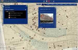
By browsing through the years via a convenient slider bar at any given location, you will find a cemetery that became a school, the arrival of rail yards and then sports stadiums, and other indicators of how the city has evolved around changes in transportation, industry, and population. You will find photographs linked to specific landmarks and buildings with links to additional information. What was demolished to make way for the Civic Arena in 1961? What sports teams played there? Now that demolition on the arena has begun in 2012, what do you think the neighborhood will look like once it is gone?
This resource is largely the result of diligent and careful work by my Esri colleague Chris Olsen. Digital maps were made by cutting and georeferencing hand-drawn paper maps, some more than 175 years old. Chris first examined the wealth of data from the Historic Pittsburgh project, including 46 volumes of Hopkins maps, which he digitally stitched together and compared it to what is on the ground today. He downloaded the raw map plates, cleaned up each image, clipped out the map data, and georeferenced each plate in ArcMap, saving each to the Web Mercator Aux Sphere projection. He then created mosaic datasets grouped by area and year, created MXD and MSD documents using the overlay map at small scales, and switched to the mosaics at large scales. Next, he cached the maps and created the web apps. The feature service on top of the maps was created from the National Registry of Historic Places and the Pittsburgh History & Landmarks Foundation. He is still adding additional content to these.
How can you use the Pittsburgh Mapping and Historical Site Viewer in your educational work?
- Joseph Kerski, Esri Education Manager
This resource shows how Pittsburgh, Pennsylvania evolved over time, from 22,433 people in 1835 to a major metropolitan area. Explore it at a small scale to get an overview of the metropolitan area. From which point did the city originally begin? Why was its river site simultaneously a blessing to the city but also a danger? What challenges did the local hilly topography pose, and how did the city grow to accommodate it? Explore the site at a large, detailed scale, studying how neighborhoods grow and expand, and how some were planned but never built. Can you find any street names that changed over time? Can you find empty lots that became buildings, schools and churches that opened and closed, and where urban renewal project s cleared neighborhoods, and then later were themselves reconstructed?

By browsing through the years via a convenient slider bar at any given location, you will find a cemetery that became a school, the arrival of rail yards and then sports stadiums, and other indicators of how the city has evolved around changes in transportation, industry, and population. You will find photographs linked to specific landmarks and buildings with links to additional information. What was demolished to make way for the Civic Arena in 1961? What sports teams played there? Now that demolition on the arena has begun in 2012, what do you think the neighborhood will look like once it is gone?
This resource is largely the result of diligent and careful work by my Esri colleague Chris Olsen. Digital maps were made by cutting and georeferencing hand-drawn paper maps, some more than 175 years old. Chris first examined the wealth of data from the Historic Pittsburgh project, including 46 volumes of Hopkins maps, which he digitally stitched together and compared it to what is on the ground today. He downloaded the raw map plates, cleaned up each image, clipped out the map data, and georeferenced each plate in ArcMap, saving each to the Web Mercator Aux Sphere projection. He then created mosaic datasets grouped by area and year, created MXD and MSD documents using the overlay map at small scales, and switched to the mosaics at large scales. Next, he cached the maps and created the web apps. The feature service on top of the maps was created from the National Registry of Historic Places and the Pittsburgh History & Landmarks Foundation. He is still adding additional content to these.
How can you use the Pittsburgh Mapping and Historical Site Viewer in your educational work?
- Joseph Kerski, Esri Education Manager
You must be a registered user to add a comment. If you've already registered, sign in. Otherwise, register and sign in.
About the Author
I believe that spatial thinking can transform education and society through the application of Geographic Information Systems for instruction, research, administration, and policy.
I hold 3 degrees in Geography, have served at NOAA, the US Census Bureau, and USGS as a cartographer and geographer, and teach a variety of F2F (Face to Face) (including T3G) and online courses. I have authored a variety of books and textbooks about the environment, STEM, GIS, and education. These include "Interpreting Our World", "Essentials of the Environment", "Tribal GIS", "The GIS Guide to Public Domain Data", "International Perspectives on Teaching and Learning with GIS In Secondary Education", "Spatial Mathematics" and others. I write for 2 blogs, 2 monthly podcasts, and a variety of journals, and have created over 5,000 videos on the Our Earth YouTube channel.
Yet, as time passes, the more I realize my own limitations and that this is a lifelong learning endeavor and thus I actively seek mentors and collaborators.
Labels
-
Administration
38 -
Announcements
44 -
Career & Tech Ed
1 -
Curriculum-Learning Resources
178 -
Education Facilities
24 -
Events
47 -
GeoInquiries
1 -
Higher Education
518 -
Informal Education
265 -
Licensing Best Practices
46 -
National Geographic MapMaker
10 -
Pedagogy and Education Theory
187 -
Schools (K - 12)
282 -
Schools (K-12)
184 -
Spatial data
24 -
STEM
3 -
Students - Higher Education
231 -
Students - K-12 Schools
85 -
Success Stories
22 -
TeacherDesk
1 -
Tech Tips
83
- « Previous
- Next »