- Home
- :
- All Communities
- :
- Products
- :
- ArcGIS Living Atlas of the World
- :
- Living Atlas Blog
- :
- Using World Imagery Wayback
Using World Imagery Wayback
- Subscribe to RSS Feed
- Mark as New
- Mark as Read
- Bookmark
- Subscribe
- Printer Friendly Page
- Report Inappropriate Content
by Bern Szukalski
The World Imagery basemap is regularly updated. When updates are made, the older imagery is replaced and is no longer visible. In most cases, the latest imagery is always preferred, but there may be reasons to use older vintage imagery. For example, there may be undesirable color variations, previous versions may align better with your GIS data, or there may be unwanted shadows or clouds. In these cases, you may want to access a previous vintage of the World Imagery basemap or layers. Another reason is that you may want to go back in time to view change that has occurred as the result of development, fires, or other events.
What is Wayback Imagery?
Wayback Imagery is a digital archive of the World Imagery basemap that enables you to access 80 versions of World Imagery captured over the past 5 years. The different vintages of imagery are published as tile layers that you can add to your maps, or can use as basemaps. Note that this archive is based on the date that it was published in the World Imagery basemap, not on the date the imagery was actually acquired, which may be older.
Here are two easy ways that you can leverage the Wayback imagery archives.
Browse the digital archive
The entire Wayback archive can be found in the Wayback Imagery group. Each record in the archive represents World Imagery as it existed on the date new imagery was published. Wayback currently supports all updated versions of World Imagery dating back to February 20, 2014. Using the archive you can view the imagery as it existed on the publish date each is represented in an ArcGIS Online item. Select the version you want, and use it as a basemap, or use it with other layers in your web map. Here’s how:
Step 1 – Choose the vintage you want
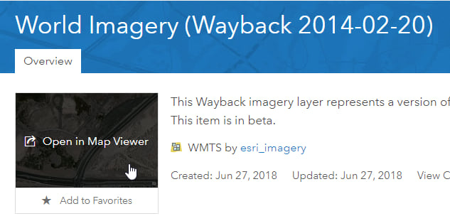
Browse the layers in the group to find the vintage you want. In this case, we’ve selected World Imagery (Wayback 2014-02-20). The title indicates the imagery in this layer was published on February 20, 2014.
Step 2 – Open the item details and add to your map
Click the title to open the item details, then click the thumbnail to add the layer to your map.
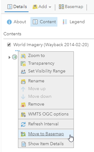
Step 3 – (Optional) Set the layer as your basemap
If you want to use the layer as a basemap, click More options (…) and Move to Basemap. After moving the layer to the basemap, you can remove other basemap layers.
Wayback app
The Wayback app delivers a way to browse previous versions of imagery using a timeline and list. Versions that resulted in local changes are presented based on location and scale. You can preview changes by hovering or selecting individual layers. Choose one or more Wayback layers to place them in a queue, when finished you can add them to a new ArcGIS online web map.
Step 1 – Open the Wayback app
You can find the Wayback app in the Wayback Imagery group mentioned above. Or, search ArcGIS Online for the Wayback app. Favorite the app or share it into one of your groups for easy access.
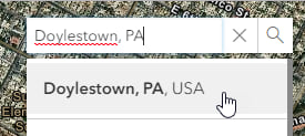
Step 2 – Zoom to your area of interest
One the app is opened, use Search to zoom to your area of interest.
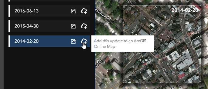
Step 3 – Examine the available imagery
Pan and zoom in or out to the desired location and level of detail, the results shown in the app are based on location and scale. The layer list shows all vintages, those with local changes are highlighted in white. In the upper left a timeline is visible, with dates with local changes highlighted. Check the box to see only the updates with local changes.

Step 4 – Select the vintage layer(s) you want to add to your map
Hover over the layers to see a preview on the map. Add layers to the queue by clicking the Add icon.
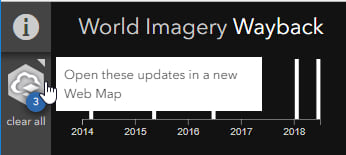
Step 5 – Add layers to your web map.
Layers you have selected are queued in the app, click Open these updates in a new web map to add the layers you’ve chosen.
In summary
Using either of these two methods (we recommend the Wayback app) you can choose the imagery for your basemap. Or, add layers of different dates to move forwards or backwards in time to see change. As other vintages become available, they will be added to the Wayback archive, and will be searchable using the Wayback app.
For more information
For more information see the following:
You must be a registered user to add a comment. If you've already registered, sign in. Otherwise, register and sign in.