- Home
- :
- All Communities
- :
- Products
- :
- Data Management
- :
- Data Management Blog
- :
- Transform Overlapping Polygons to Contiguous Polyg...
Transform Overlapping Polygons to Contiguous Polygons Listing the Overlapping Attributes
- Subscribe to RSS Feed
- Mark as New
- Mark as Read
- Bookmark
- Subscribe
- Printer Friendly Page
- Report Inappropriate Content
The process described in this Blog requires an Advanced license.
Some polygon feature classes contain a set of overlapping features that accurately represent the boundaries of the attribute(s) that each polygon contains. For example, polygon boundaries could each represent the area covered by a different policy and if more than one policy applied to a property then multiple policy area boundaries would overlap. Typically they can't be symbolized with solid fills and have to use hatch symbols and any classification of the features as being overlapped cannot identify which portion is overlapped.

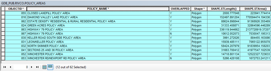
This configuration is not useful if you want to select just the overlapping portions of the policy areas or you need to intersect this feature class with another feature class without duplicating portions of the other feature class where these features overlap.
This Blog provides a method for transforming overlapping polygons like this into a new polygon feature class that contains separate contiguous polygons with no overlaps and combines any attribute values that originally overlapped into a list that defines each new feature. The steps of the process are:
- Run the Union tool in the Analysis toolbox under the Overlay toolset on just the feature class that contains the overlapping polygons
- Run the Multipart to Singlepart tool in the Data Management toolbox under the Features toolset on the Union output to separate all multipart polygons into individual polygons for each part.
- Run the Feature to Point Tool in the Data Management toolbox under the Features toolset on the Multipart to Singlepart output with the Inside option checked to extract the attributes to a set of points that fall inside of the polygon that they came from. NOTE: If slivers are extremely small or narrow the tool can fail to run. You may want to select features that have large areas or that are small with a larger thinness ratios. If your length field is in feet and your area field is in square feet you could 1000 square feet as the cut off for larger features and do the selection with this SQL: (SHAPE_Area >= 1000 OR 4 * 3.14 * Shape_Area / (Shape_Length * Shape_Length) > 0.3 AND SHAPE_Area < 1000))
- Run the Feature to Line tool in the Data Management toolbox under the Features toolset on the Multipart to Singlepart output with the no relationship option and do not preserve attributes.
- Run the Feature to Polygon tool in the Data Management toolbox under the Features toolset on the Feature to Line output to create unique single-part, contiguous polygons for all the areas enclosed by the lines.
- Run the Spatial Join tool in the Analysis toolbox under the Overlay toolset with the following settings:
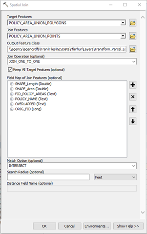
- Make the Feature to Polygon output the Target Features
- Make the Feature to Point output the Join Features.
- Use the JOIN_ONE_TO_ONE option
- Use the Keep all target features option.
- For the attributes you want to transfer to the Polygons from the Point, in the field map right click each field and access its properties. Change the following in the Output Field Properties:
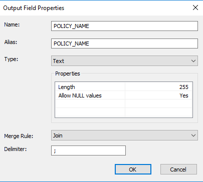
- Make sure to change the field Type is set to Text if it not Text already
- Change the field Length to 255 characters (possibly more if the tool fails because the output field is too small and you are outputting to a geodatabase)
- Change the field Merge Rule to Join
- Set the Delimiter to a character or set characters that are not contained in the original attributes, like a semicolon (";").
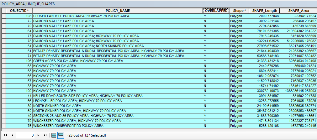
- The final output features will have the following characteristics:
- Features with attributes that do not contain the delimiter character(s) were not overlapping and the attribute is identical to the original feature. These features can be selected with an SQL expression similar to:
NOT POLICY_NAME LIKE '%;%' - Features with attributes that contain the delimiter character(s) were originally overlapping, but now are a single feature that has a list of all the attributes of the original overlapping features separated by the delimiter. These features can be selected with an SQL expression similar to:
POLICY_NAME LIKE '%;%' - Features with Null attributes were not originally features, but they were empty spaces fully enclosed by the original features that can be eliminated or merged into surrounding features if they are slivers. These features can be selected with an SQL expression similar to:
POLICY_NAME IS NULL
- Features with attributes that do not contain the delimiter character(s) were not overlapping and the attribute is identical to the original feature. These features can be selected with an SQL expression similar to:
- The features in the picture below with solid fills are just the portions of the original polygons that overlapped. The features are contiguous without any overlaps and the attributes associated with each portion list all of the overlapping values in a single feature. They can be symbolized or selected separately and won't cause feature duplication due to overlaps when they are intersected with other feature classes.

I hope you find this useful.
You must be a registered user to add a comment. If you've already registered, sign in. Otherwise, register and sign in.