Integration of 3D Plant & 3D Utility design models into 3D geospatial platform
- Subscribe to RSS Feed
- Mark as New
- Mark as Read
- Bookmark
- Subscribe
- Printer Friendly Page
- Report Inappropriate Content
designO&G downstream large-scale operations drive intelligent infrastructure and assets management throughout the operating life of assets, which significantly impact on safety, operational efficiency, production predictability, and overall profitability.
One of the positive effects on asset information management is to seamlessly integrate 3D process plant models, utility 3D models, visualization, simulation and mobility in 3D GIS platform with ‘real-time’ capability.
The first step for 3D GIS platform is to build 3D GIS solution database in one eco-system, meanwhile seamlessly interoperating with others.
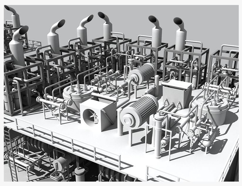
The construction of 3D GIS database are required to integrate different data and data models, in particular, 3D Process Plant Models (refinery, gas plant, petrochemical, power, etc.) and 3D Utility Models (powerlines, pipelines, etc.).
| 3D Plant Model (as 3D Block in ArcScene) | 3D Powerline Model (3D Scene in CityEngine) |
|---|---|
 |  |
| After reducing the details of 3D plant models by 100-500 times, CityEngine can be used to convert into multipatch via Collada; But, there is no effective way to geolocate the block onto the earth in ArcScene or ArcGlobe in Edit mode | 3D powerlines model converted as 3D block in 3D scene |
However, it is huge challenging in theory and practice to integrate 3D Plant models into geospatial solution platforms like ESRI ArcGIS, because of the different computer precisions between 3D GIS and 3D Plant Models (mostly 3D CAD design models by Microstation and Intergraph in O&G), which demonstrate the following major issues during conversion from 3D CAD to 3D GIS via open standard formats like Collada:
1. too details with huge size (i.e., very common to have 1 - 2 GB or more , if via Collada);
2. non-georeferenced (i.e., most of plant engineers /designers are still not aware of the spatial technology)
3. loss of intelligence (i.e., all attributes/ annotations associated with objects in 3D CAD model are lost in 3D GIS)
Worth to mention, asset information models in 3D GIS platform should provide an accurate digital representation of the physical asset (which for many infrastructure assets is in a constant state of flux) and detailed knowledge of the asset context (including the decisions behind why the assets were designed the way they were, as well as how the asset was constructed and modified).
Let's compare major capabilities from two products (MicroStation, AutoCAD) for 3D CAD plant modeling (attachment)...
Secondly, how to convert the following major 3D process plant models into 3D geospatial solution platforms?
Intergraph PDS / MicroStation (v6, 7) | MicroStation (v8) / i-models / Hypermodeling / Bentley Map 3D | Intergraph Smart 3D / GeoMedia® 3D |
|---|---|---|
| Still many 3D models in PDS as corporate standand; especially, massive 3D plant models were delivered in PDS | direct and seamless integration with 3D Plant & Utility models via i-models; and directly edit over 3D CAD in DWG or DGN, LiDAR point clouds (TranScan) within Bentley Map 3D ... | interoperability with both graphics and data attributes of foreign CAD models and PDS models; enabling an even richer, centrally-managed 3D ecosystem, especially, with Bentley Map 3D /i-models |
So, what is the operational solution to meet those challenges?
You must be a registered user to add a comment. If you've already registered, sign in. Otherwise, register and sign in.